Below, you will find a sample of maps that I have designed/conceived during the past few years. Enjoy!
This map shows the location of selected defence-industrial production sites in Saudi Arabia. It is part of a section on defence industries I contributed to the Middle East chapter of The Military Balance 2025. This one looks so professional because it was designed by the IISS Design team.

Source: IISS Military Balance 2025
This map shows the location of selected ports and military facilities in Djibouti and Somalia. It breaks them down by country; operation vs interest; built vs planned; and commercial vs military, adding nuance and crucial detail that is often missed in ongoing conversations about port and basing access. It’s also part of a chapter I wrote on the competition for ports and bases for this report: Lawless Seas, Contested Shores - Piracy, Smuggling and the Scramble for Port Access in the Horn of Africa. The map was designed by the IISS design team.

This map shows a selection of infrastructure newly-built or under construction, including ports, port terminals, and logistics parks in Qatar, Saudi Arabia, and the UAE. It is part of a piece I wrote for the Strategic Comments series, which you can find here: The push to increase trade connectivity in the Arabian Peninsula.
This one, too, was designed by the IISS Design team.

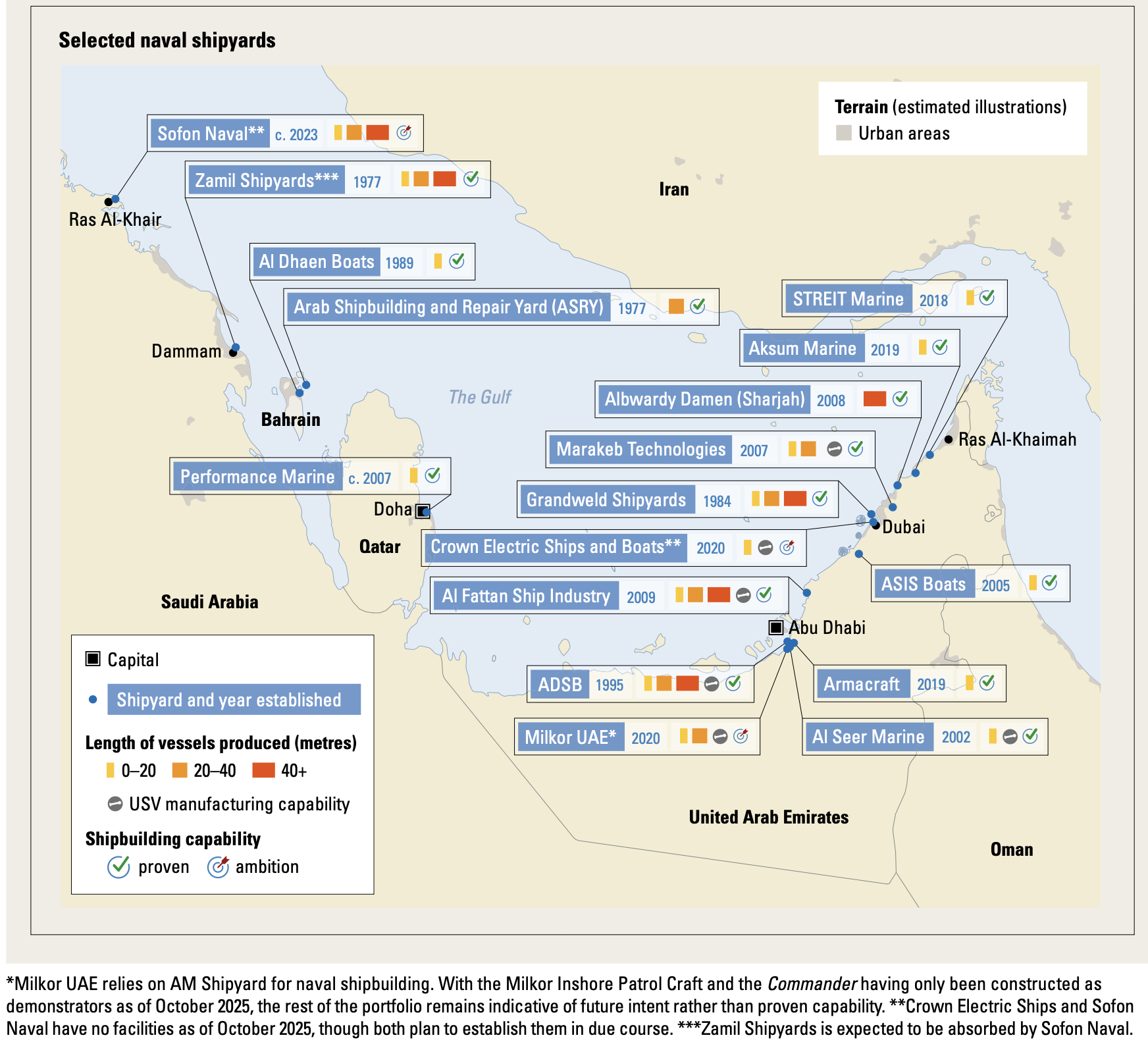
This map of Arab Gulf naval shipbuilding is part of the Middle East chapter in The Military Balance 2026. Here’s an accompanying excerpt:
While most Arab Gulf states have some shipbuilding or maintenance capability, the bulk of this resides in the UAE, with neighbouring Saudi Arabia seeking to translate its significant procurement spend into industrial capability in the future.
The UAE’s naval-shipbuilding ecosystem is led by Abu Dhabi Ship Building (ADSB), which serves as the sector’s national champion within a relatively diverse industry. ADSB’s capacity remains limited: it is capable of producing vessels only up to the size of a small corvette, constrained by an 80-metre syncrolift and shallow channel depth. At least three other shipyards – Albwardy Damen, Al Fattan Ship Industry and Grandweld Shipyards – are also capable of building large vessels, while several smaller firms produce patrol boats and uninhabited surface vessels (USVs). This fosters innovation and competition, particularly in the patrol-craft segment. Additional commercial shipyards in the UAE, though not currently engaged in naval shipbuilding, could possibly be mobilised to scale up production if needed. In the future, ADSB plans to expand to a satellite location capable of handling vessels up to 120 metres long.
By contrast, although Saudi Arabia’s shipbuilding ecosystem is currently less mature, the country’s plans are significantly more ambitious – Riyadh aims to localise 100% of its naval shipbuilding. To accelerate progress and bolster efficiency, Saudi Arabia is consolidating naval-shipbuilding activities under Sofon Naval, a subsidiary of new company Sofon Holding. Sofon Naval’s planned shipyard, still in the design phase as of October 2025, is expected to accommodate much larger vessels – including landing platform docks and destroyers. However, the path forward is not without challenges. Unlike the UAE, Saudi Arabia lacks a strong base of commercial shipyards or a competitive network of patrol-boat and USV manufacturers upon which to build greater capabilities. That means its ambitions risk being impeded by inconsistent demand for shipbuilding work.
Bahrain, Kuwait and Qatar collectively host several smaller shipyards, mostly focused on maintenance, repair and overhaul and small-patrol-boat construction – far below the scale and ambition seen in the UAE and Saudi Arabia.
The map below, which shows Chinese presence in Middle Eastern ports, was designed for a research paper I wrote in the Spring of 2023. I compiled the data from a variety of sources that helped me triangulate, enhancing the validity of my findings. Some of the most relevant sources I used are company websites, open-source information about investments and MoUs, and academic and policy pieces written by Isaac B. Kardon and Grant Rhode, among others.
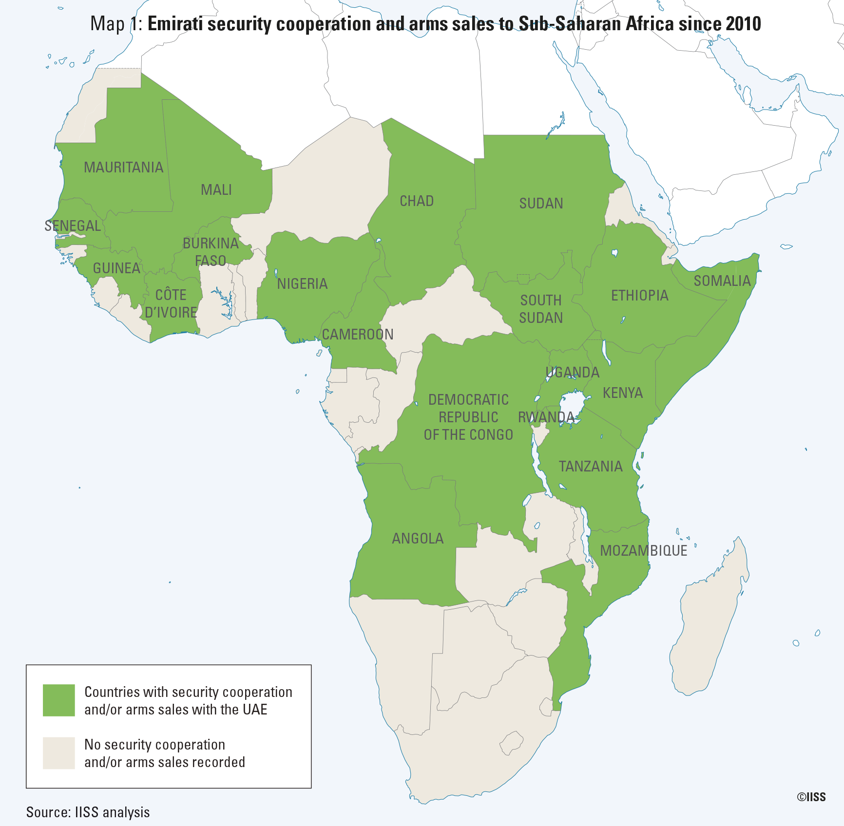
The map below is part of a piece where I track security cooperation and arms trade interactions between the GCC countries and Sub-Saharan Africa.
“Saudi Arabia and Qatar have made sporadic donations of military equipment to selected sub-Saharan partners. Bahrain’s engagement in the region is largely confined to a small-scale deployment in Somalia. As for Oman and Kuwait, there is no known tangible security cooperation. The United Arab Emirates (UAE), on the other hand, has ramped up its security cooperation with sub-Saharan Africa in the past few years, overshadowing its GCC neighbours.”
I designed the map below as a visual support for a paper I wrote in the Spring of 2023, where I examined India - Middle East relations from a ports/maritime perspective. There are two major players that deserve a closer look: the UAE’s DP World and India’s Adani Ports. Over 30% of the goods coming in and out of India go through DP World-operated terminals, an insanely huge amount! In the next few years, we might see other GCC-based port operators such as the UAE’s AD Ports Group, Qatar’s QTerminals, or Saudi Arabia’s RSGT invest in more ports across South Asia.
The map below shows a crescent or axis that extends from the port of Dekheila to the west all the way to Sokhna, in the southern entrance of the Suez Canal. I designed this map to visually support my argument in a paper I wrote in the Spring of 2023, where I traced Chinese investment and interest in Middle Eastern ports. This axis matters because Chinese companies currently have operations in four of these ports and will soon be operating a terminal in Sokhna, the fifth one. This will grant Chinese port operators a strategic location in both entrances of the Suez Canal from where they could potentially engage in surveillance activities. It will also give significant leverage to these Chinese companies over the most populated Arab country, as they will be overseeing a lot of what comes in and out of the country.
The map below shows the cooperation agreements between LOGINK, a unified digital logistics and trade platform administered by China’s Ministry of Transport, and various European ports. This map is part of an article I wrote for the Center of Maritime Strategy, which ranked among the Center’s most read/popular content in 2023!
This map shows the location of shipbuilding companies, shipyards, and docks in the UAE. Unlike most other countries in the Arabian Peninsula, the UAE has developed a unique domestic shipbuilding capacity, led by Abu Dhabi Shipbuilding and Al Fattan, among others. This is part of a paper I wrote for the Gulf International Forum, published in 2024: Securing the Seas: Examining Changing Saudi & Emirati Naval Capabilities
This map shows the location of maritime and naval academies in the UAE, most of which are concentrated in Abu Dhabi and Dubai. Thanks to the centrality of port operations and shipping in the UAE’s economy, the country now hosts a significant amount of entities offering maritime-related training. Also part of the paper for the Gulf International Forum I mentioned above.
The map below shows Saudi, Emirati, and Chinese presence in Red Sea ports. I designed this map for a research paper I wrote in the fall of 2022, using a variety of sources including company websites, news media, and other reports.
The map below shows the military facilities of the Royal Saudi Armed Forces near the Red Sea. This map is part of Chapter 3 of my master’s thesis, where I argued that Saudi Arabia retains a higher capacity than the UAE to apply force when and where needed in the Red Sea, as it has significantly more available military capabilities, and sits geographically closer to the Red Sea. All the information is open source, from a map that no longer loads on Sinews of War and Trade, and two other sites called WhoWasInCommand and Scramble-Dutch Aviation Society-Orders of Battle.